EnglishDeutschРусскийShqipČeština‎FrançaisMagyarItalianoPolskiRomânăСрпски језикEspañol
diving in montenegro

Navionics Bathometric Survey

Navionics Bathometric Survey

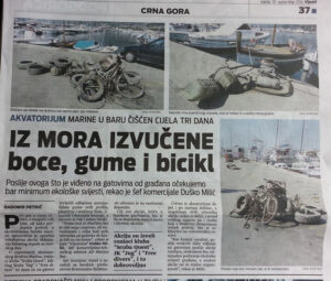
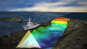
During months of May and June of 2013, crew of Downunder and Scuba Quest dive center performed detailed bathometric of-shore mapping of the Montenegrin coastline. Our client Navionics is a largest provider of nautical electronics maps in the world. Their maps are used by Lowrance, Garmin, C-Map, Track Map… Project was prompted by the need of more detailed bathometric survey of the Montenegrin sea bed and of shore installations, in order to improve safety of nautical traffic.
We have covered total of 1500 km of the coastline spanning from Kotor to Ada Bojana. State of the art Lawrence sonar were used to map an record the data.

Sonar


Latest news

Dive With Me…Forever

In September of 2015 a young man from Bar, asked me to make his wedding proposal most memorable. He wanted to try Discover Scuba and propose to his girlfriend during the dive.

Read More »

MEDCEM “Save the Posedonia” Project

Our friends from MEDCEM asked for our help in providing logistical support and diving services for their new project “ECONOMIC BENEFITS OF SUSTAINABLE DEVELOPMENT AND POTENTIAL BLUE CARBON VALUE OF FUTURE KATIC MPA”.

Read More »

MPA “Katic” Management Plan

Following the Pilot MPA Project “Katic”, Montenegrin Ministry For Sustainable Development and Tourism and Italian Ministry of Environment, Land and Sea, had published management plan for the Marine Protected Area “Katic”.

Read More »

Follow Us On